February 12, 2024
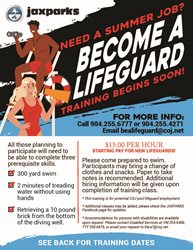
Need a summer job? Join our Aquatics Team and Become a Lifeguard! Training has started but there are plenty of dates remaining. The starting pay is $15 per hour, you must be at least 15 years of age and complete the required training.
Training will be held at one of these locations:
Cecil - 13611 Normand Blvd., 32221
Charles Clark - 8793 Sibbald Rd., 32208
Woodland Acres - 8200 Kona Ave., 32211
November 27, 2023

September 29, 2023
Share your thoughts, desires, and/or needs in our survey today.

September 29, 2023
Greenscape Celebration Park will be closed, starting on Monday, October 2nd.

February 01, 2023
We want to hear from you!

January 13, 2023
It's time to recruit lifeguards for City pools.
Jaxparks Aquatics is gearing up for this year's swim season and are looking to hire lifeguards! There are three prerequisite skills that are required to complete:
- 300 yard swim
- 2 minutes of treading water without using hands
- Retrieve a 10 pound brick from the bottom of the diving well
See training dates and locations below:
September 27, 2022
Oceanfront parks and preserves affected in anticipation of Hurricane Ian.
August 31, 2022
Are you ready for some football?!
About Us
The Department of Parks, Recreation and Community Services serves diverse populations of all ages and abilities through
parks, recreation activities and programs,
conservation and
marine resources, Sports & Entertainment,
senior services,
social services,
disabled services and
extension services.
The department provides the day to day management and oversight for one of the largest, diverse, and unique urban park systems in the nation with over 400 park and recreational sites within the city limits consisting of a variety of parks, open spaces,
trails,
athletic programs and facilities,
community and
senior centers, beaches, golf courses,
aquatic facilities,
boat and kayak launches,
nature preserves, along with an amphitheater,
arboretum and an
equestrian center. Recreation programs and activities are available year-round for our park users of all ages and abilities.
In our Jacksonville parks, there is always something to do, see, and experience daily!
Another important function of the department is serving those most in need through our Senior, Disabled and Social Services Divisions. We provide day to day support for the populations most in need of these critical services. For those in need of any of these services, we are here for you.
We provide training and support to our professionals and volunteers that are part of our agricultural and landscaping industry by providing agricultural education through our Duval County Extension office. If you are in need of these services, we can help.
Parks Partnership Program
Are you interested in enhancing any of our parks or programming in Duval County? If you are interested, we have a Parks Partnership Program designed to promote private support of our City's expansive park system. For more information, email us at jaxparks@coj.net for more information
. Click below to view the JaxParks Amenities Catalog and Pricing Guide:
JaxParks Amenities Catalog
JaxParks Amenity Pricing (Last Updated May 2017)
Department Fees
_________________________________________________________________
Director of Parks, Recreation and Community Services, Daryl Joseph; (904) 255-7907;
DJoseph@coj.net
Chief of Recreation and Community Programming, Dan Piastuck (904) 255-7918;
DPiastuck@coj.net
Chief of Natural and Marine Resources, Jill Enz; (904) 255-7907;
JEnz@coj.net
Chief of Disabled Services, Kara Tucker; (904) 255-5691;
KaraT@coj.net
Chief of Social Services, Johnnetta Moore; (904) 255-3322;
JMoore@coj.net
Chief of Senior Services, Gloria Crawford; (904) 255-5401;
GCrawford@coj.net
Chief of Sports & Entertainment, Alex Alston; (904) 255-5453;
AAlex@coj.net
Extension Director of Duval County Extension Office, Stephanie Toelle; (904) 255-7450 ;
SToelle@coj.net
Permits - JaxParks Permitting; (904) 255-7930; JaxparksPermitting@coj.net
Jaxparks@coj.net
February 12, 2024
Need a summer job? Join our Aquatics Team and Become a Lifeguard! Training has started but there are plenty of dates remaining. The starting pay is $15 per hour, you must be at least 15 years of age and complete the required training.
Training will be held at one of these locations:
Cecil - 13611 Normand Blvd., 32221
Charles Clark - 8793 Sibbald Rd., 32208
Woodland Acres - 8200 Kona Ave., 32211
November 27, 2023
September 29, 2023
Share your thoughts, desires, and/or needs in our survey today.
September 29, 2023
Greenscape Celebration Park will be closed, starting on Monday, October 2nd.
February 01, 2023
We want to hear from you!
January 13, 2023
It's time to recruit lifeguards for City pools.
Jaxparks Aquatics is gearing up for this year's swim season and are looking to hire lifeguards! There are three prerequisite skills that are required to complete:
- 300 yard swim
- 2 minutes of treading water without using hands
- Retrieve a 10 pound brick from the bottom of the diving well
See training dates and locations below:
September 27, 2022
Oceanfront parks and preserves affected in anticipation of Hurricane Ian.
August 31, 2022
Are you ready for some football?!