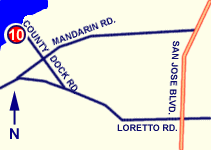
DRIVING DIRECTIONS:
From I-295/County Road 13
(San Jose Boulevard) Intersection
1. Head SOUTH on SAN JOSE BLVD
2. Turn RIGHT onto LORETTO RD
3. Merge RIGHT onto COUNTY DOCK RD
4. Landing is at terminus of County Dock Road.
|
 |
| PROVIDES ACCESS TO: |
NUMBER OF TRAILER PARKING SPACES: |
| St. Johns River |
No trailer parking at ramp |
| OVERFLOW PARKING: |
DOCKING AND STAGING: |
| Some available off site |
fixed dock for fishing only |
| ADA ACCESSIBLE: |
HOURS OF OPERATION: |
| No |
6 a.m. - 10 p.m. |
| NUMBER OF RAMP LANES: |
AMENITIES: |
| 1 |
Restroom, fishing area, picnic area, park area |
| COORDINATES: |
|
| N 30° 10.023' W 81° 38.831' |
|
| SPECIAL CONDITIONS: |
VESSEL USE RATING: |
| No parking for trailers at ramp; unimproved ramp; shallow. |
D = hand launch only |
| VESSEL USE RATING GUIDE |
A= unlimited;
B= vessels less than 22 Feet |
C = jon boats and jet skis;
D= hand launch only |
|