Planned Aerial Spraying I Planned Neighborhood Spraying I Where We Have Treated
Mosquito Control sprays insecticide with low-flying aircraft over rural and residential areas of Duval County. Missions are typically flown during dusk or dawn. Spraying is necessary to control biting adult mosquitoes, which pose a potential public health threat by spreading West Nile virus. For more information on Naled, the active ingredient in the adulticide utilized by JMCD in aerial spray applications, please reference the EPA's website.
Mosquito Control typically schedules aerial spray missions for the morning hours, but evening flights may be conducted. Flights may be rescheduled based on weather conditions. Select the area to learn more about planned aerial spray flights scheduled. Please remember that all flights are weather permitting. Check this site daily for updates.
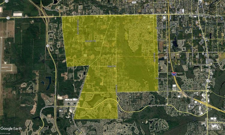
There is an aerial spray mission planned for Thursday 10/19/23 in the evening, weather permitting, and an additional mission planned for Monday 10/23/23, also in the evening.
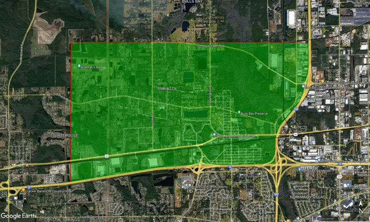
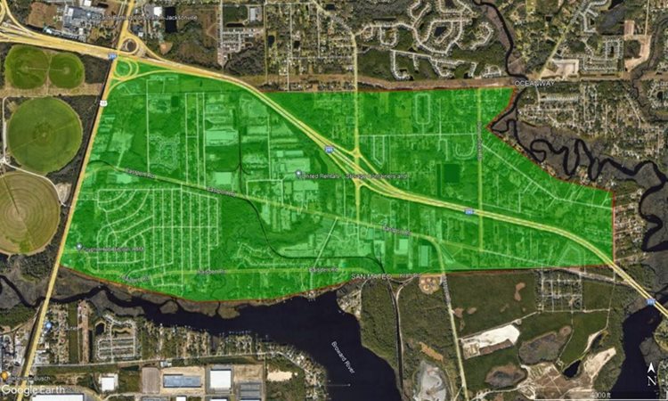
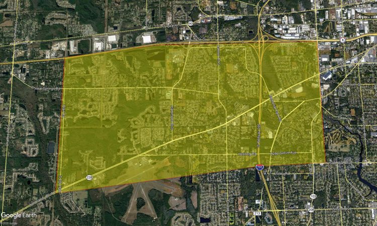
The Thursday mission centers around the Marietta neighborhood between Whitehouse and the 295, and extending north-south between Commonwealth and the I-10.
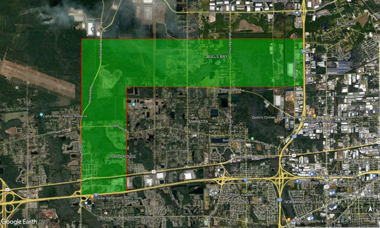
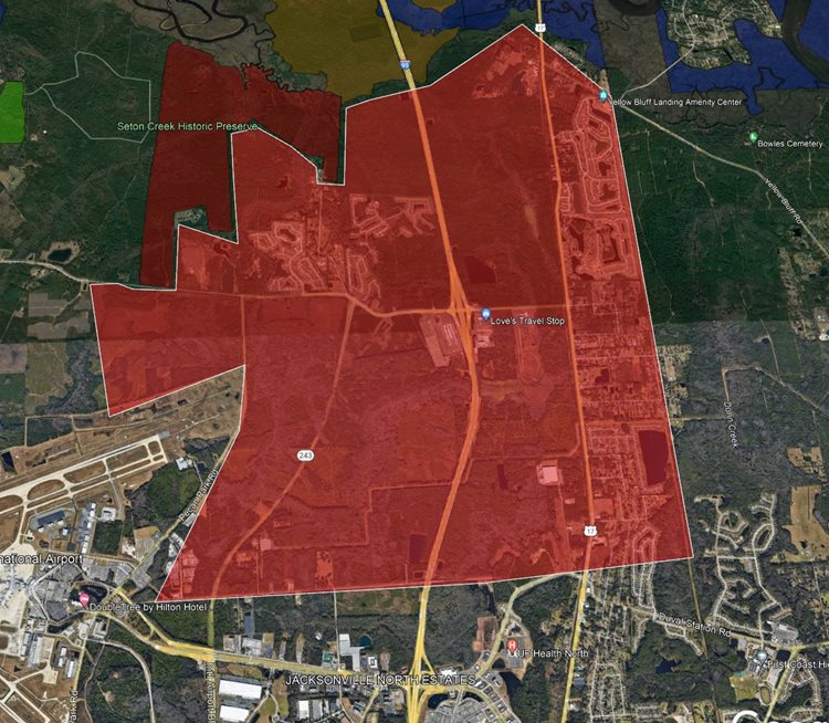
The Monday (10/23/23) mission is in an L-shape, extending the northern and western borders of the prior Thursday (10/19/23) million to Chaffee rd on the west, and the Bulls Bay area to the north.
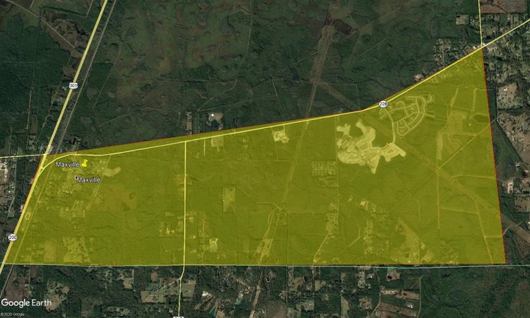
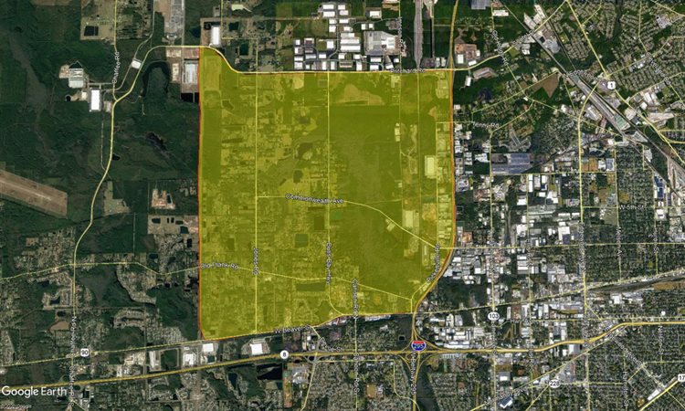
There is an aerial spray mission planned for Wednesday 10/18/23, in the evening. If weather forces a cancelation it will be moved to the next favorable day.
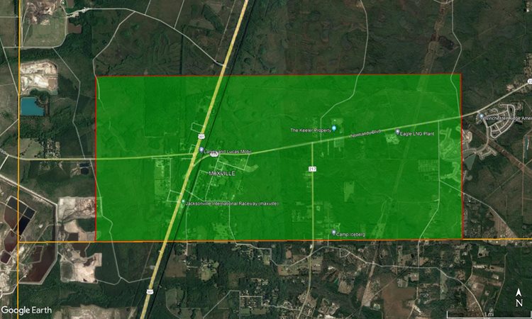
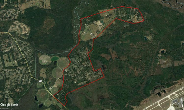
An area centered around Maxville and extending primarily into wooded areas in the surround.
There is an aerial spray mission planned for Thursday 10/12/23 in the evening. If weather cancels, the mission will take place the following Monday 10/16/23. There are two locations being sprayed.
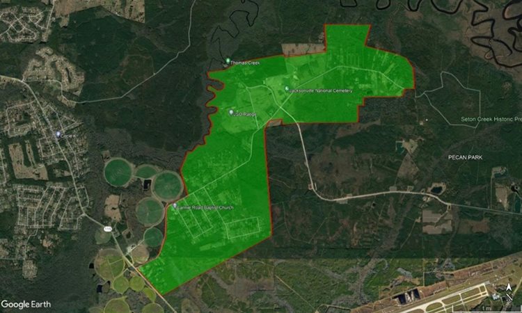
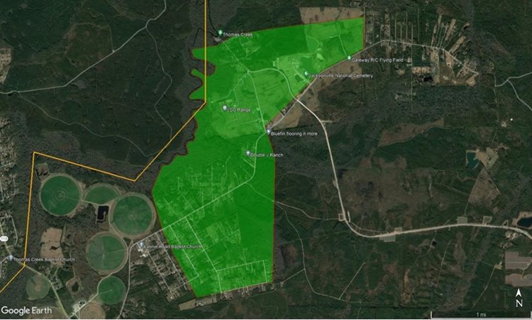
An area along Lannie rd and surrounding residential areas
An area straddling I-295 between Main St and Davis rd.
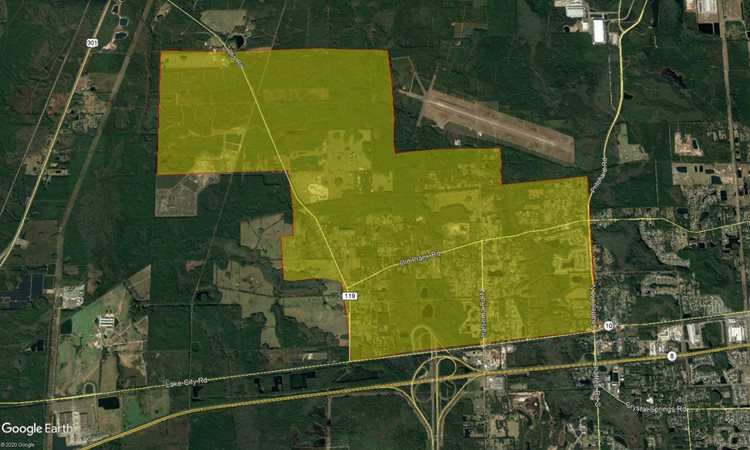
There is an aerial spray mission planned for Thursday 10/05/23 in the evening, contingent on weather. The alternate is Monday 10/09/23
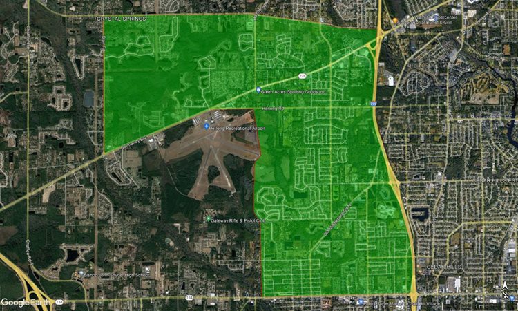
An L-shaped area between Blair rd and 295, extending from Crystal Springs down to 103rd.
There is an aerial spray mission plannned for Monday 9/18/23 in the evening, contingent on weather
The area around Lannie rd and Lem Turner, near the prison and surrounding environs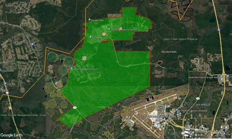
The area around Lannie rd and Lem Turner, near the prison and surrounding environs
There is an aerial spray mission planned for Monday 8/28/23 in the evening, contingent on weather.
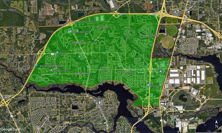
An area defined by the curve of the I-295, Trout River, and the I-95 including the Highlands and Garden City neighborhoods
There are a pair of aerial missions planned for Monday 8/21/23 and Tuesday 8/22/23, both of which will be in the early morning. In the event of incliment weather, alternative dates will be the next suitable day.
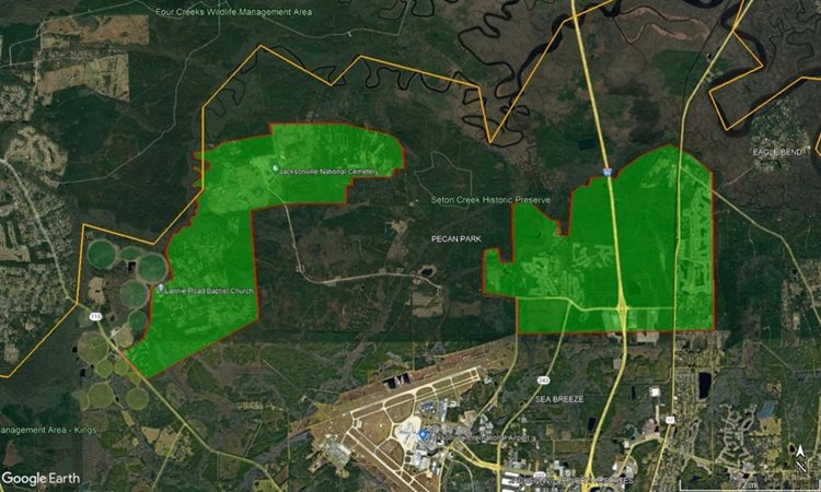
Two sites, one extending along the length of Lannie rd, and the other consisting of the Pecan Park neighborhood as well as the northern portion of Oceanway. This is the Augist 21st mission.
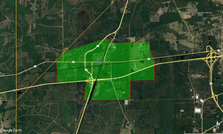
The August 22nd mission consists of the area around Baldwin.
There is an aerial mission scheduled for Wednesday December 14th, in the evening. Subject to change due to weather.
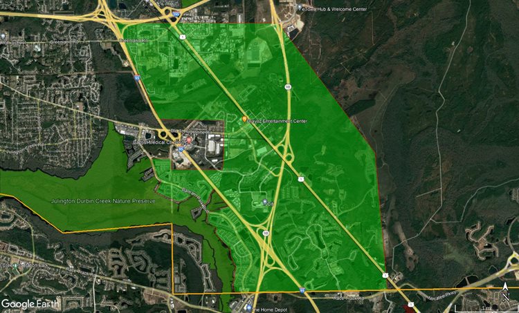
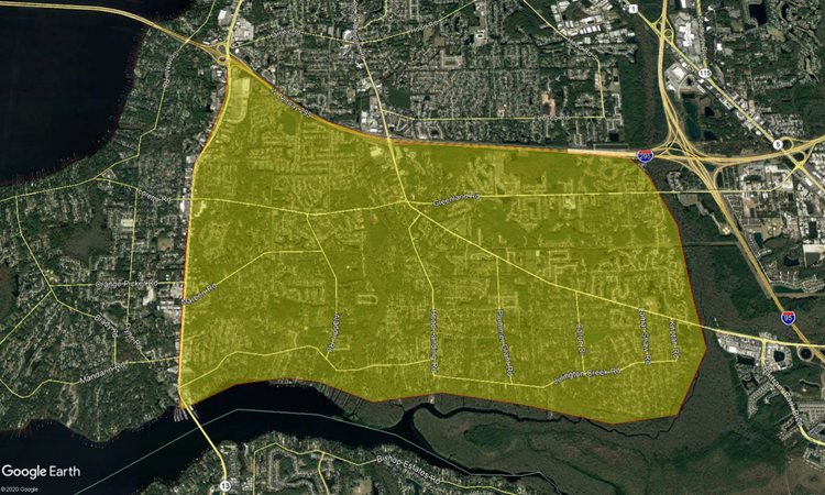
An area bounded in the north by the 295, the south by Race Track rd, the west by Julington Creek Preserve and the East by Holsinger blvd.
There is an aerial mission scheduled for Thursday September 15th, in the early morning. Subject to change due to weather

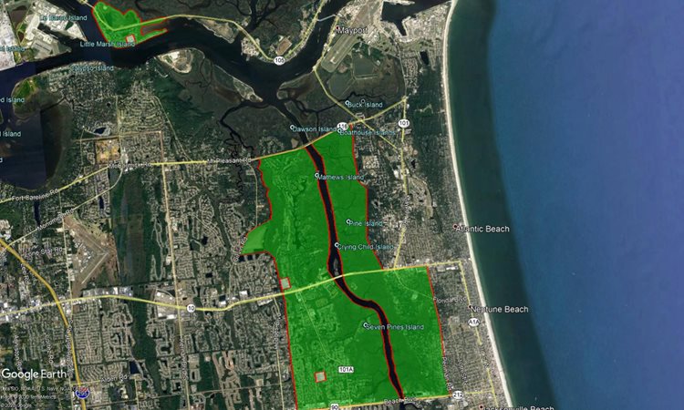
An area consisting of Little Marsh hill, and areas along Heckscher drive immediately west
There are a pair of aerial missions planned for the morning of Wednesday September 14th, 2022. Subject to change due to to weather with a backup date of Thursday September 15th.
Area along Lannie rd near the correctional facility
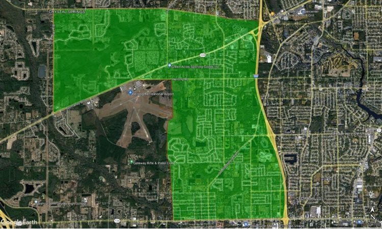
An between Herlong airfield the 295, and between Crystal Springs and Normandy blvd. Extends south to 103rd st.
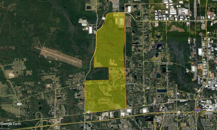
There is an aerial mission planned for the morning of Wednesday July 28th, 2022. Subject to change due to weather.
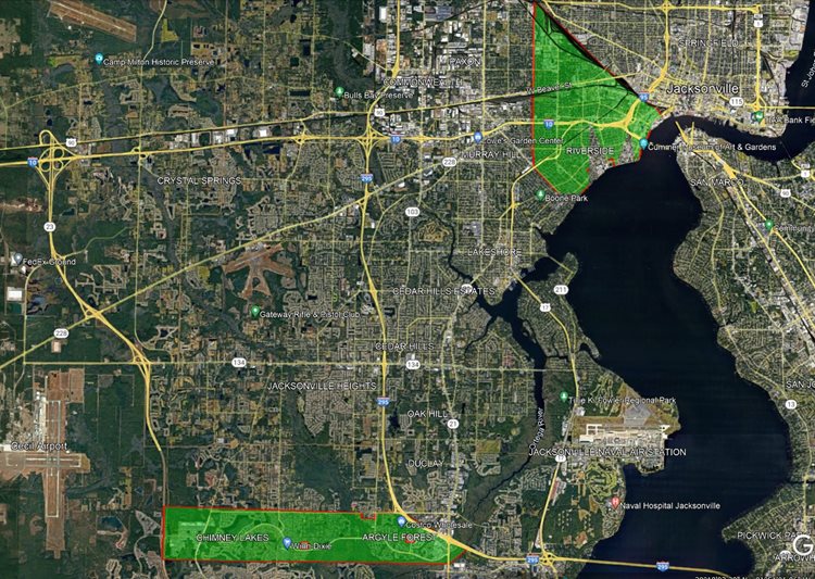
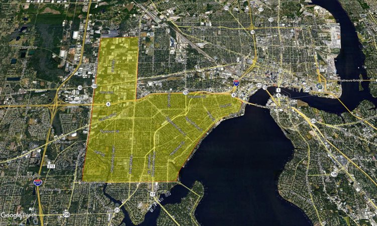
Two sites, one consisting of the Brooklyn, Riverside, Murray Hill, Avondale, and Lackawanna neighborhoods from the railroad yard south to Edgewood and from the St John's River to Nelson st.. The second consists of the Chimney Lakes and Argyle Forest areas between Collins rd and the County Line.
There is an aerial mission planned for the evening of Monday April 4th, 2022. Subject to change due to weather.
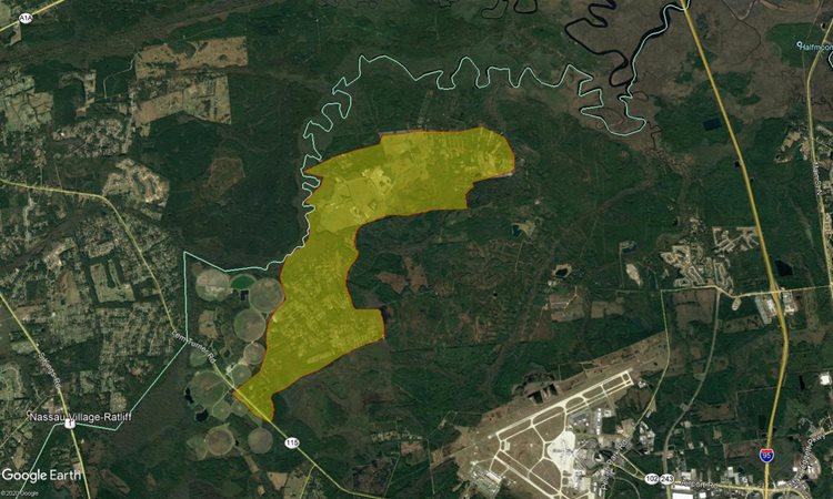
An area with a northern border of the preserves straddling the Duval/Nassau County line, a southern border of Owens road. The eastern border is Hidden Lake, and on the west is the northern third of the airport .
There is an aerial mission planned for Tuesday July 16th, 2021, subject to changes due to weather.
Text Description: A relatively small area consisting of the Mongtomery Correctional Facility and it's immediate surrounds along Lannie road.
There is an aerial mission planned for Monday, July 26th 2021. (This Mission has been cancelled as of Monday Morning, July 26th)
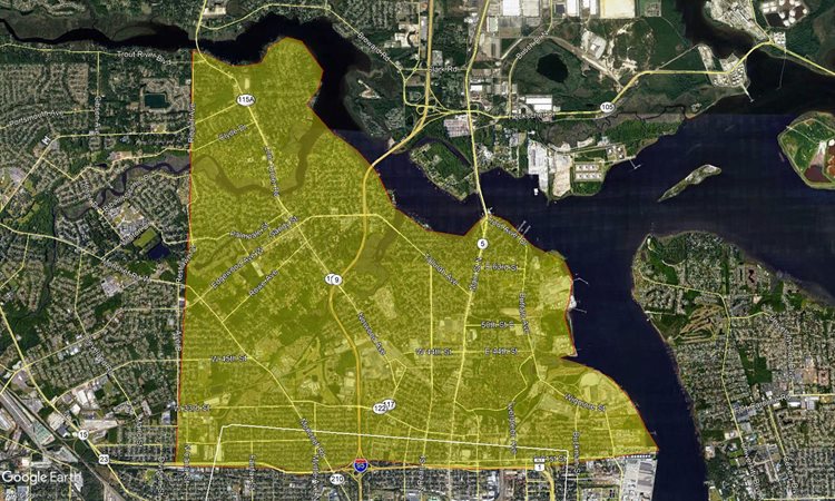
Text Description: The northern end of urban core and extending into Springfield, from Broadway to 50th st, and extending to the east as far as Canal st
There are a pair of missions planned for Wednesday July 14th 2021 in the evening, contingent on weather which may extend that window.
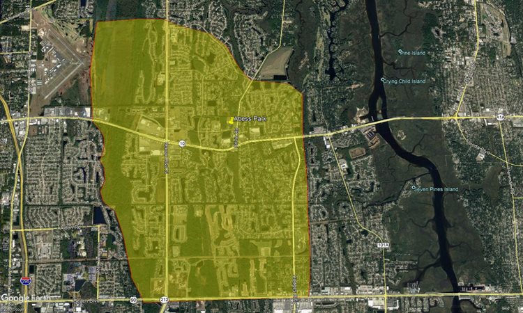
Text Description: An area defined as the San Marco neighborhood and surround, from the Arlington Expressway to San Clerc rd, and extending from the St. Johns River to approximately Butler boulevard and Grove Park boulevard.
There is a planned spray mission for Monday July 12th, 2021 in the evening, contingent on weather which may extend that window through the week.
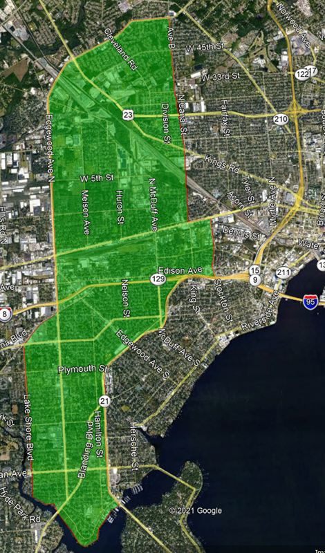
Text description: A complex spray path defined by the Lake Shore blvd and the curve of Edgewood ave, and extending to Roosevelt blvd and Canal st.
There is a planned spray mission for Thursday October 29th, 2020 in the evening, contingent on weather. Addendum: Due to adverse weather conditions, this mission has been tentatively rescheduled for Wednesday November 4th, 2020.
Text Description: An area defined as Lannie rd and adjacent streets and non-protected wilderness areas.
There is a planned spray mission for Thursday September 24th, 2020 in the early morning, contingent on weather and airspace availability. This supplants the earlier planned mission, which was conducted on the 23rd.
Text Description: This spray mission is bordered on the west by Otis rd, and the east by Celery ave N. Its southern border is Beaver st, while the northern extent is the intersection between Dillon and Otis.
There is a planned spray mission for ThursdaySeptember 24th 2020 in the early morning, weather permitting. This was moved from the 22nd due to adverse weather conditions.
Text Description: An area defined by the lines of Jammes rd on the east and Bulls Bay hwy on the west, and stretching between Wilson and Commonwealth.
There is a planned spray mission for Tuesday September 15th 2020 in the early morning, weather permitting
Text Description: An area defined as Lannie rd and adjacent streets and non-protected wilderness areas.
There are planned spray missions on August 12th and 13th, 2020 in the early morning, weather permitting
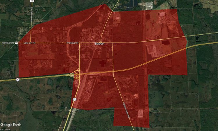
Text Description: The township of Baldwin, and surrounding woodland areas
on August 13th
Text Description: The residential and non-protected woodland areas along Lannie rd.
There are planned spray missions on July 8th, 2020 in the early morning, weather permitting
Text Description: An area along Lannie rd from Lem Turner to the terminus of Lannie rd and including unprotected forest and residential areas
Text Description: A spray zone running from Yellow Water rd to the 301; and from Normandy blvd to the county line.
There are planned spray missions on July 1st, 2020 in the evening, weather permitting
Text Description: A mostly rectangular area extending from Ricker rd in the East to the north-south line of Old Middleburg rd on the west, and extending primarily from 103rd to Collins, but having a projection south of Collins to the couny line between Shindler dr and Old Middleburg rd.
Text Description: From north to south this area runs from San Juan to the I-10, but features a projection between Edgewood rd and Lane ave that extends to West 12th st. Lane ave forms the western border, while the river forms the eastern boundary.
There are planned spray missions on June 30th, 2020 in the evening, weather permitting.

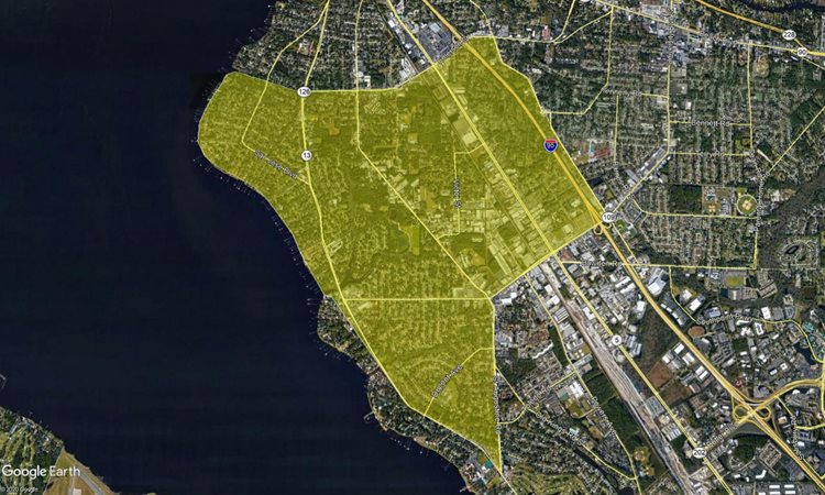
Text Description: Mandarin south of the 295 and west of San Jose blvd.
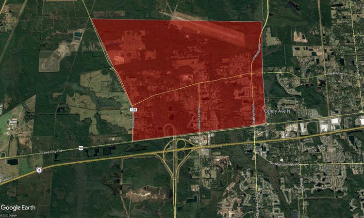
Text Desciption: A long strip of land south of Pritchard and north of Beaver, between Chaffee rd and Cathy Tripp ln
Text decrioption: A more or less curvirectancular area north of Beach blvd and extending between Atlantic blvd and Mt Pleasant dr, and from just east of Hodges blvd west until Alfa Romeo dr
There are planned spray mission on June 29th, 2020 in the evening, weather permitting.
Text description: A proposed treatment zone south of of the 295 beltway to Old Bull Bay, and extending east until the wetland forest along I-95.
Text Description: a region starting just east of the I-95 and extending west toward the river, bound on the north by Emerson st and to the south primarily by University Blvd, but with a projection extending down in a triangle from the intersection of Univrsity and St Augustine rd toward and terminating at Larida ln
Text Description: This area lies neatly between Beach blvd and Butler ave on the north-south, and Southside ave and Dean on the east-west.
There is a planned spray mission on June 25th, 2020 in the evening, weather permitting.
Text Description: This area straddles Normandy blvd between Blair rd and Lane ave, from just south of the I-10 to just south of the line of San Juan ave
There is a planned spray mission on June 25th, 2020 in the evening, weather permitting.
Text Description: An area south of 103rd street and terminating just south of Argyle Forest blvd, between Cecil Commerce Center pkwy and the 295 beltway.
There is a planned spray mission on June 24th, 2020 in the evening, weather permitting.
Text Description: An area enclosed by Beaver st, Pritchard rd, the 295 beltway, and a small residential street just west of Maple ave called Arbee rd
There is a planned spray mission on June 24th, 2020 in the evening, weather permitting.
Text Description: The residential neighborhoods west of Chaffee rd along Old Plank and Otis
There is a planned spray mission on June 23rd, 2020 in the evening, weather permitting.
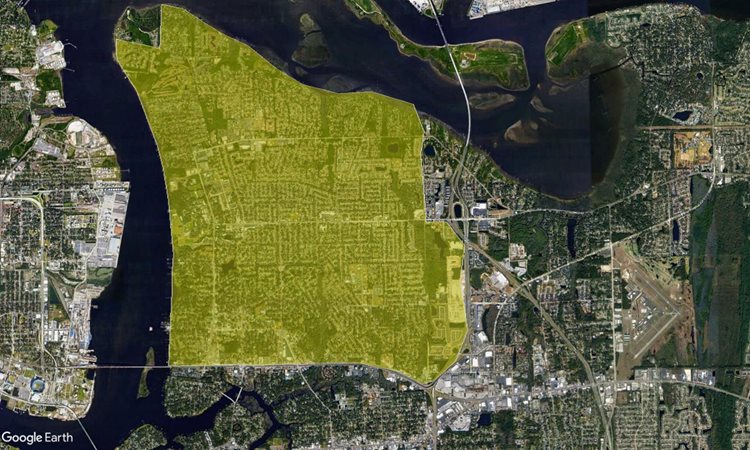
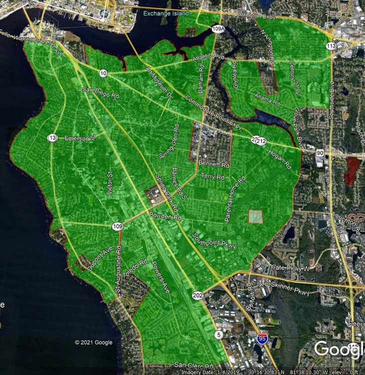
Tex Description: A region of NW Arlington, bound on the south by the Arlington Expressway, and the east primarily by the Southside Connector, bordered to the west and north by the St. Johns river and Mill Cover respectively. There is an included exclusion for conservation land at the NW extreme of the region.
There is a planned spray mission on June 23rd, 2020 in the evening, weather permitting.
Text Description: An area defined by San Juan ave, the St. Johns River, and Lane ave, with a northern border along W. 12th street between Lane ave and Edgewood ave N, and the I-10 for the remainder.
There is a planned spray mission on June 22nd, 2020 in the evening, weather permitting.
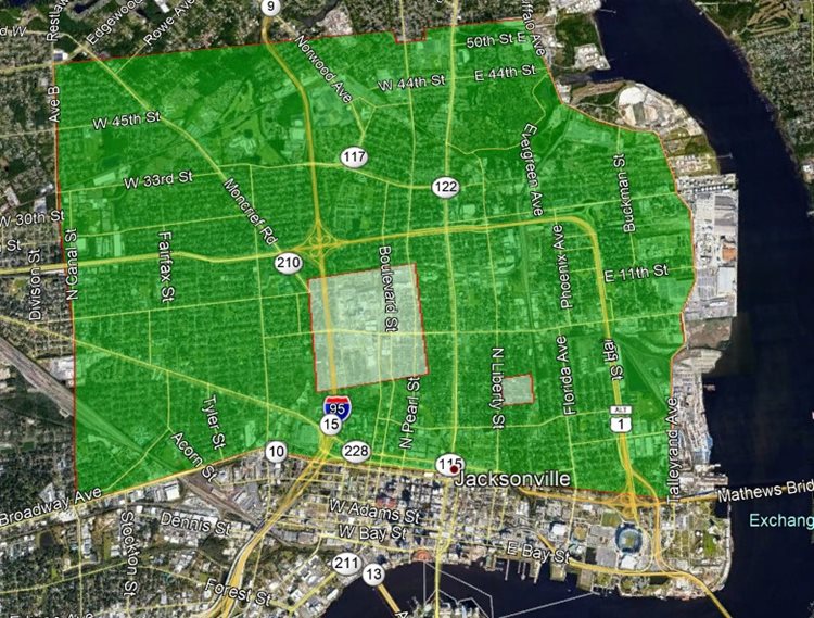
Text Description: An area with the St.Johns River bounding the eastern side, the Trout River bounding the North, with the US 1 to the South, and bounded on the west by the line of Avenue B
There is a planned spray mission on June 22nd, 2020 in the evening, weather permitting.
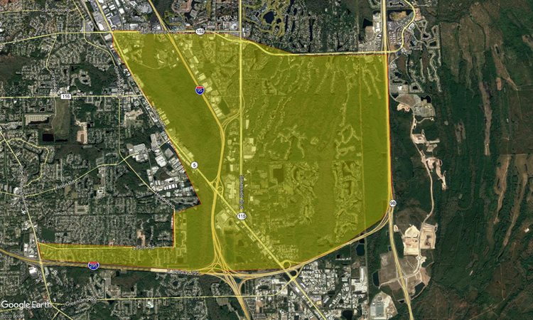
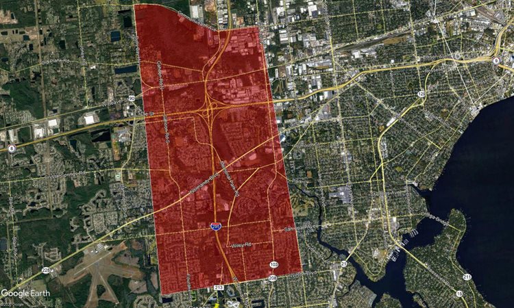
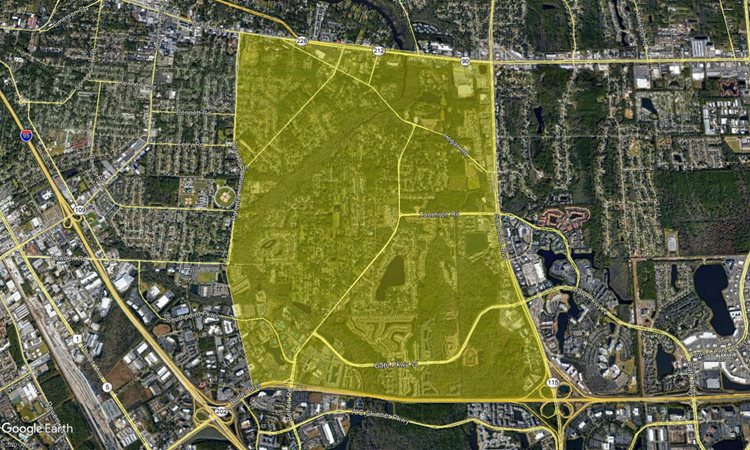
Text Description: This treatment area is bordered on the north by Baymeadows, and on both the south and east by the curve formed in the 295 loop. While the west is mostly bordering the Phillips highway, there is also a projection over some of the residential neighborhoods immediately north of the 295 west of that boundary.
There is a planned spray mission on June 18th, 2020 in the early morning, weather permitting.
Text Description: Little Marsh Island, an the neighborhoods bordering the intercoastal waterway between Beach blvd and Mt Pleasant rd.
Mosquito Control typically sprays areas in Jacksonville between 7 p.m. and 11 p.m., Monday through Thursday. Starting mid-April, crews will be dispatched around Jacksonville to fog for adult-biting mosquitoes. We typically do not list the areas we are planning to fog by truck, but check out our Ground Fogging page to see if we have sprayed your neighborhood recently.
Visit the Where We Have Treated page to see where we have been working to control mosquitoes with our aerial program. Check out Ground Fogging page to see what neighborhoods our fog trucks were spraying. You can also refer to your CARE number to check the status of your request using the 630-CITY online form.
Return to Mosquito Control Home