Atlas# 2 Area of Town: Northside
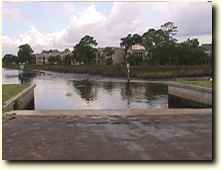
500 Maxwell Road (Map It)Bert Maxwell ramp is a well used ramp for local fishermen and provides the best direct access to the lower Trout River. The ramp was improved in 1993 with new bulkheads, however the entrance channel has silted in considerably and is difficult for larger boats at low tide. There is a large parking area but, because of this ramp's popularity, the lot is often full on weekends.
Click here to link to the NOAA web site for weather conditions and tide reports.
|
  |
DRIVING DIRECTIONS:
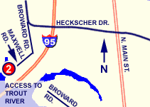
From Heckscher Dr. Westbound: 1. Turn LEFT onto BROWARD RD after crossing I-95
2. Turn RIGHT onto MAXWELL ROAD
3. Ramp is at end of Maxwell Road. |
 |
| PROVIDES ACCESS TO: |
NUMBER OF TRAILER PARKING SPACES: |
| Lower Trout River |
40+ |
| OVERFLOW PARKING: |
DOCKING AND STAGING: |
| Some available in area |
Floating docks
|
| ADA ACCESSIBLE: |
HOURS OF OPERATION: |
| No |
24 hours / 7 days |
| NUMBER OF RAMP LANES: |
AMENITIES: |
| 2 |
fishing, picnic area, restrooms
|
| COORDINATES: |
|
| N 30° 24.178' W 81° 39.815' |
|
| SPECIAL CONDITIONS: |
VESSEL USE RATING: |
| Some shoaling near ramp; vertical clearance limitations down river |
B = Vessels less than 22 feet |
| VESSEL USE RATING GUIDE |
A= unlimited;
B= vessels less than 22 Feet |
C = jon boats and jet skis;
D= hand launch only |
|