UPDATE #10: HURRICANE MATTHEW
October 07, 2016
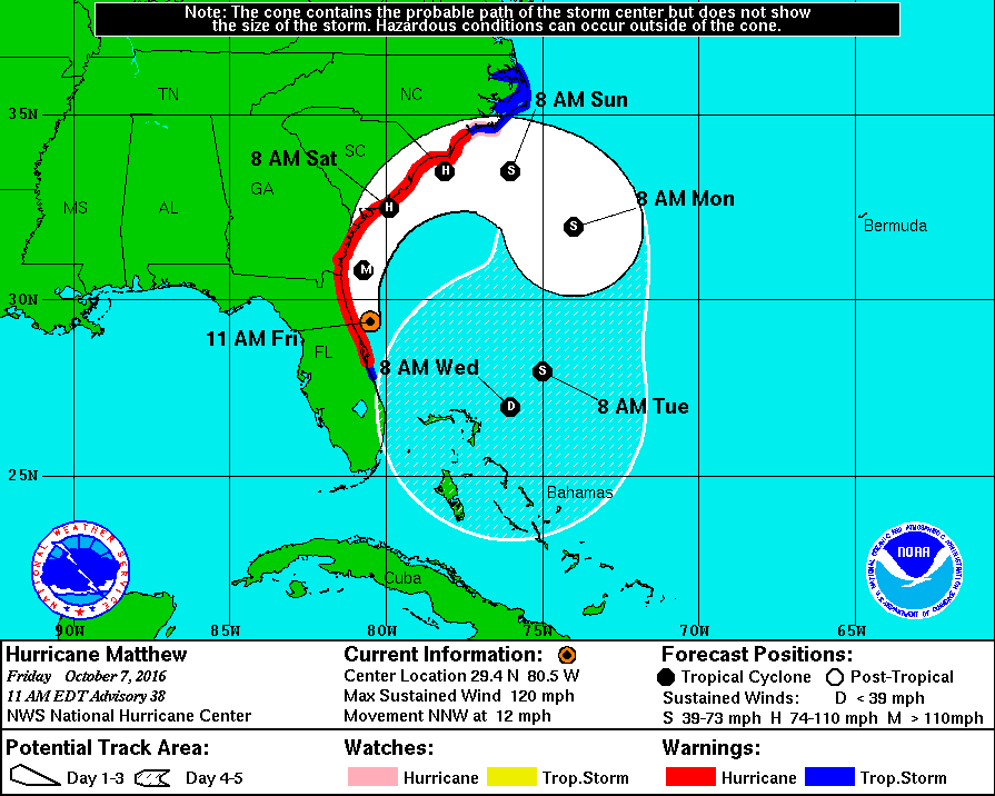
Friday, Oct. 7, 11:15 a.m.
Hurricane Matthew Continues Devastating Track Along Florida Coastline
Wind threshold conditions are now impacting Jacksonville and the beaches. JSO and JFRD continue to monitor storm conditions and will make every effort to respond to citizen needs.
Storm Updates:
-
Hurricane conditions are expected in 3-6 hours.
-
Water levels continue to rise with storm surges, with highest levels at 1-2 p.m. and 1-2 a.m. tonight.
-
Expected rainfall is 6-10 inches along the coast and 4-6 inches inland.
-
Hurricane force winds are expected to be 60-80 mph with 90 mph gusts along the coast, and 40-60 mph with 80 mph gust inland.
-
A Storm Surge Warning has been issued for Duval County.
-
Storm surges are expected to be 7-9 ft. above ground level at the ocean front with battering breakers between 20-25 ft. Storm surges of 6-9 ft. are predicted along the Intracoastal and the northern St. Johns River, up to 3 ft. in Downtown Jacksonville, Ortega, and Julington Creek.
-
Elevated water levels will remain within the St. Johns basin for about one week.
-
Jacksonville remains under a Hurricane Warning.
-
According to National Weather Service, conditions will continue to deteriorate with the impact of storm being felt through Friday evening and into Saturday morning.
-
The area is also under a flood watch through Saturday.
-
The St. Johns River will continue to oscillate after the storm passes causing continuing flooding issues.
-
Conditions are expected to deteriorate through noon Saturday.
-
Catastrophic storm surge and destructive wind patterns pose a significant threat to life and property.
-
President Barack Obama has declared a pre-landfall emergency.
-
Duval County remains in a State of Emergency.
-
The Emergency Operations Center (EOC) is continuing their 24-hour staffing levels implemented to track and monitor storm conditions and their impact on Jacksonville.
Bridge Closures:
-
Dames Point Bridge
-
Atlantic Boulevard Intracoastal Waterway Bridge
Shelters:
-
Seven shelters are now open.
-
The Legends Center, Atlantic Coast High School, Twin Lakes Elementary School, Landmark Middle School are at capacity.
-
Shelters with availability include:
-
Chimney Lakes Elementary School (9353 Staples Mill Dr. – 32244; General population, pet friendly)
-
Mandarin Middle School (5100 Hood Rd. – 32257; Special needs, general population, pet friendly)
-
NEW – Oceanway Elementary School (12555 Gillespie Ave. – 32218; general population)
-
Those staying in shelters must bring their own food, water and bedding.
Rumor Control:
-
The Fuller Warren Bridge is open at this time. The Dames Point Bridge and Atlantic Boulevard Intracoastal Waterway Bridge are currently closed.
-
There are no sheltered animals in any evacuation zones. The Jacksonville Beach Animal Shelter evacuated to the City of Jacksonville’s shelter. The Jacksonville shelter has more than enough capacity to accommodate the animals. It is a state-of-the-art facility. All cages are indoors and animals are protected. The Jacksonville Humane Society has emptied their facility and sent all animals to foster care. CITIZENS SHOULD NOT DROP THEIR ANIMALS OFF AT ANIMAL CARE AND PROTECTIVE SERVICES. Animal shelters are not housing for personal pets.
-
There are no reports of looting in the Jacksonville Beach area. Police are continuing to patrol and monitor the area.
-
Jacksonville University is NOT mandating any evacuations from campus as JU residence halls are not currently in an evacuation zone.
-
630-CITY and JaxReady are operational. Please recognize that they are experiencing high volumes slowing operations. Encourage citizens to use the JaxReady app and 630-CITY website as call waiting times may exceed an hour.
Services:
-
Hospitals:
-
Hospitals in evacuation zones (Baptist Beaches and Nassau) have evacuated patients to other hospital facilities. All other hospital emergency rooms are open to serve patients with critical needs.
-
JEA Updates
-
As of 10:40 a.m., JEA reports 6,904 customers are experiencing power outages throughout the city. Crews will be working to restore any outages that occur prior to the main body of the storm until they can no longer work safely.
-
JEA has 413 employees preparing and coordinating prior to the storm. Crews will be working to restore any outages that occur prior to the main body of the storm until they can no longer work safely.
-
All employees are in place for the duration of the storm and restoration.
-
Water and sewer outages will begin to occur after east of the Intercostal. Water utility services will not be reinstated until staff is able to inspect systems, inspect any damage, make any necessary repairs, and provide a safe and healthy water supply to customers. Once services are reinstated, a boil water notice will remain in effect until the water supply is deemed safe.
-
Do not connect generators directly to home wiring. Generators can "backfeed" into the power lines attached to homes, which can increase voltage anywhere on the JEA system and seriously injure or kill a JEA lineman or your neighbor on the same line. For more information, go to https://www.jea.com/Outage_Center/Storm_Safety/Generator_Safety/
-
JEA’s Downtown Business Office is closed.
-
JEA employees are now focusing only on storm preparation and restoration.
-
As of today, JEA will not disconnect service for non-pay or connect new service through the storm.
-
Customers can Text REG to MyJEA (69532) to register to notify JEA of an outage. They can also go to jea.com/alerts to sign up. With this, citizens experiencing outages can text OUT to MYJEA.
-
JEA expects widespread outages and customers should be prepared for multiple days without services.
-
Public Works
-
High winds have forced Public Works to suspend services until Saturday. To date they have addressed 39 stormwater related issues, 15 tree issues and 27 malfunctioning traffic signals. Citizens are reminded to treat malfunctioning traffic lights as 4-way stops.
-
Waste collections normally scheduled for Friday have been rescheduled for Sunday, Oct. 9.
-
JTA Updates
-
There is no JTA bus service today.
-
Visit Jacksonville Update
-
People are encouraged go to VISIT FLORIDA’s site to get hotel availability. People can also use TripAdvisor, Expedia and other hotel booking engines to find hotel rooms.
-
USPS mail will not be delivered on Friday and Saturday.
-
JAX Airport update:
-
All arrivals and departures for Oct. 7 are cancelled.
-
Passengers should contact their airline – NOT the airport – for the most updated status of their flight.
-
Economy Lots 1 and 2 are closed until further notice. Other parking facilities will remain open until they reach capacity. Call the parking office at (904) 741.2277 for more information.
Traffic:
-
Traffic Updates (JSO)
-
Citizens are encouraged to stay where they are. Storm conditions are predicted to worsen.
-
Traffic Updates (FDOT)
-
There are five convenient ways to receive traffic updates:
-
Download the free Florida 511 mobile app available on Google Play or Apple App Store.
-
Call 511 toll free for updates in English and Spanish.
-
Visit FL511.com for interactive roadway maps showing traffic congestion and crashes, travel times and traffic camera views.
-
Sign up for a “My Florida 511” account at FL511.com to create custom routes and register for email, text or phone alerts.
-
Follow one of the 13 statewide, regional or roadway-specific Twitter feeds (#FL511).
-
Expect many major corridors to be flooded, including construction zones. Use extreme caution and heed local emergency information.
Military:
-
NAS Jacksonville has closed. Only essential personnel will have access to the base.
Other Updates:
Updates will be provided regularly via the City’s
website and social media
accounts.